(NOTE: During the March 12 meeting, this item was moved to the March 19 agenda.)
San Rafael, CA – A focused assessment of Highway 37 between Highway 101 and Petaluma River will begin this spring to help recommend improvements that increase resiliency to flooding along the corridor. The Marin County Board of Supervisors will decide whether to move forward with the study at its March 12 session in Suite 330 of the Marin County Civic Center in San Rafael.
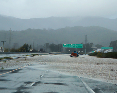
 The Novato stretch of Highway 37, which is owned and maintained by the California Department of Transportation (Caltrans), has a long track record of being inundated by flooding from high tides, sea level rise, and freshwater storm runoff.
The stretch of highway, owned and maintained by the California Department of Transportation (Caltrans), has a long track record of being inundated by flooding from high tides, sea level rise, and freshwater runoff from increasingly significant storms. The corridor was
recently closed for several days due to storm-related flooding and closed for about a month in early 2017 due to heavy rains and high tides. While Marin County Flood Control and Water Conservation District-maintained infrastructure was not directly related to either of those incidents, all stakeholder assets in the corridor could potentially be vulnerable and need to be addressed for resiliency.
The study of the corridor will cost $148,000 and has been awarded a Senate Bill 1 (SB1) Adaptation Planning grant from Caltrans for $130,170. The remaining $17,830 will be covered by the County of Marin, the Flood Control District and the Transportation Authority of Marin (TAM).
The project is intended to assess a range of recent studies of Highway 37, as well as sea level rise studies, that have been conducted by various local and state agencies. The project’s scope will be to distill those past studies and other information collected to date, gather additional data as appropriate and develop recommendations for resiliency improvements along the corridor from Highway 101 to Petaluma River. The project is solely an assessment and is not intended to implement physical improvements at this time along the highway corridor.
The results of the study, which is expected to be completed by winter 2020, will help determine a recommended approach for Caltrans and key stakeholders for moving forward. The approach will seek to be both cost-effective and provide the most asset protection possible. That may entail incremental improvements along the vulnerable corridor to ease the severity of the ongoing incidents. Potential solutions that may be considered include raising Highway 37, enhancing nearby existing levees, or a combination of solutions. Regardless of the recommended solution, any future comprehensive improvement project would be a massive undertaking.
“The detailed study will provide an approach that can be used to pursue funding on the scale that is likely to be necessary,” said Dan Dawson, Marin County Department of Public Works’ Principal Transportation Planner. “Given the scope of any potential solution and the related environmental considerations, it’s too early in the process to speculate on a potential timeline to complete appropriate and durable solutions.”
Not only is the issue highly complex, it also requires coordination between a variety of stakeholder agencies and entities, many of which have similarly vulnerable assets adjacent to the corridor. Those include Caltrans, Pacific Gas & Electric, Sonoma Marin Area Rail Transit, Marin County Flood Control and Water Conservation District, Novato Sanitary District, private landowners, California Coastal Conservancy, and the California State Water Resources Board.
The County of Marin has prioritized climate change adaptation the past few years and is assessing current and future effects of sea level rise. The Flood Control District is addressing the need by making improvements to District-owned flood infrastructure whenever possible and planning specific projects that target the issue. More information on the County’s sea level rise efforts can be found online.