San Rafael, CA — Seasonal high tides often cause flooding along shoreline communities and low-lying roadways of Marin County, which can be exacerbated during winter storms. Tide-related flooding can happen whether it’s raining or not, and such instances are likely to occur over the next few months and may begin as soon as this Thursday morning, November 4.
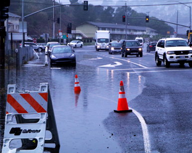 The entrance to the Manzanita Park & Ride Lot in southern Marin is one of the areas that typically floods during king tides, drastically affecting traffic flow.
Based on tide predictions published by the National Oceanic and Atmospheric Administration (NOAA), tides levels that could be high enough to cause roadway flooding in parts of Marin, primarily coastal areas, are expected November 4-8, December 2-7, and December 30 to January 5. If a high tide coincides with a significant storm, a tidal surge can occur, causing higher than predicted water levels.
Drivers should allow extra time for trips and should be prepared to use alternative routes to avoid localized flooding on roadways. Travelers should always avoid driving through ponded water, as even six inches of standing water can stall a vehicle.
“High tides can bring localized flooding to coastal areas, such as Tam Junction, even on sunny days,” said Roger Leventhal, Senior Civil Engineer for the Marin County Department of Public Works (DPW). “However, when coupled with a significant storm, these predicted high tides could increase impact to various areas of Marin where signs of sea level rise are already causing year-round tidal flooding issues.”
DPW and the Marin County Flood Control and Water Conservation District are urging residents and visitors to be aware of the seasonal high tides that have been predicted. DPW and the District prepare year-round for the rainy season, conducting various maintenance tasks intended to help reduce the risk of flooding across Marin. Residents are encouraged to plan ahead and take action on their own property to help mitigate flood risk.
In advance of forecasted storms, it is recommended that private property owners clear dead leaves from driveway pipes, rooftop gutters, and storm drains. Dead foliage should be disposed of in compost bins, not left in street gutters where it could clog neighborhood drainage systems. Those living in flood-prone areas should test their sump pumps and stock up on sandbags (available at most hardware stores), as well as learn how to properly use them prior to storms. Additionally, ReadyMarin.org provides many detailed resources, including emergency grab-and-go packing checklists, that can be helpful for residents to prepare for the unexpected.
The following chart shows predicted high tides at or above 6.3 feet through January 2022 at the NOAA San Francisco tide gauge. If significant rainfall occurs during a high tide of 6.3 feet or more, the likelihood of localized flooding increases for coastal communities and other historically susceptible areas, such as North San Pedro Road through China Camp in outer San Rafael, Greenwood Cove Drive in Tiburon, Lucky Drive in Greenbrae, Redwood Highway at Greenbrae Boardwalk, Marin City and Manzanita Park & Ride near Tam Junction.
November 2021
| Day |
Elevation in Feet (MLLW) |
|
Thursday, November 4, 11:24 a.m.
|
6.49
|
|
Friday, November 5, 12:00 p.m.
|
6.72
|
|
Saturday, November 6, 12:40 p.m.
|
6.81
|
|
Sunday, November 7, 12:24 p.m.
|
6.72
|
|
Monday, November 8, 1:14 p.m.
|
6.45
|
December 2021
| Day |
Elevation in Feet (MLLW) |
|
Thursday, December 2, 9:08 a.m.
|
6.68
|
|
Friday, December 3, 9:47 a.m.
|
6.97
|
|
Saturday, December 4, 10:30 a.m.
|
7.13
|
|
Sunday, December 5, 11:16 a.m.
|
7.11
|
|
Monday, December 6, 12:05 p.m.
|
6.9
|
|
Tuesday, December 7, 12:58 p.m.
|
6.51
|
Thursday, December 30, 7:52 a.m.
|
6.6
|
|
Friday, December 31, 8:37 a.m.
|
6.94
|
January 2022
| Day |
Elevation in Feet (MLLW) |
|
Saturday, January 1, 9:21 a.m.
|
7.13
|
|
Sunday, January 2, 10:11 a.m.
|
7.21
|
|
Monday, January 3, 11:02 a.m.
|
7.13
|
|
Tuesday, January 4, 11:54 a.m.
|
6.86
|
|
Wednesday, January 5, 12:47 p.m.
|
6.4
|
Future projections by the California King Tides Project indicate that annual king tides, which are extreme high tides, could become the new normal tides as sea level rise continues. King tides occur when the earth, moon and sun are aligned to exert the maximum upward gravitational pull on the tides, thereby increasing overall water elevations. The project also predicts that there will be an increase in daily tidal flooding as sea levels rise. In the same vein, the County of Marin released the Marin Shoreline Sea Level Rise Vulnerability Assessment in 2017, a comprehensive study that showed the expected impacts that sea level rise will have on flooding along the eastern Marin shoreline. For southern Marin, a detailed interactive guide to sea level rise flooding can be found on the Richardson Bay Resilience website.
Travelers can check 511.org for latest traffic and transit information. During storm events, DPW’s Twitter, Marin County Sheriff’s Office’s Twitter, the California Highway Patrol (CHP) traffic website and CHP Marin’s Twitter are all excellent resources for travelers and residents looking for updates. Another resource is the Marin County emergency portal, which provides a range on helpful information and links. Additionally, weather gauges showing rainfall and tide elevations can be viewed in real-time at Marin County’s OneRain webpage.