San Rafael, CA –A report released April 6 shows the significant impact that sea level rise (SLR) will have on Marin County’s landscape and infrastructure in the coming years. Future flooding will impact highways, streets, and public transportation, as well as cause extensive property damage. It will jeopardize utilities including wastewater treatment, restrict access for emergency response services, and reduce marsh habitats.
 An aerial view of eastern Novato illustrates the vulnerability of sea level rise.
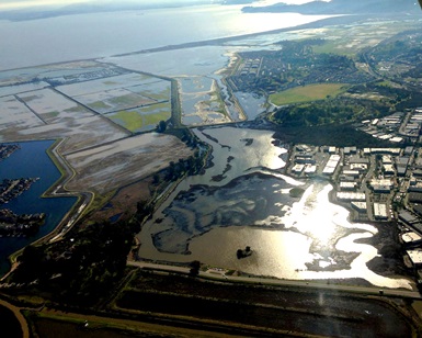
 The
Marin Shoreline SLR Vulnerability Assessment uses the best available scientific data to identify specific risks for the region and the scope of flooding. Three public meetings will be held to introduce the report:
- April 19, 7:00 p.m. to 9:00 p.m. at Pickleweed Park in San Rafael
- April 25, 7:00 p.m. to 9:00 p.m. at Mill Valley Community Center
- April 29, 10:00 a.m. to noon at Novato City Hall
The 163-year-old Golden Gate tide gauge, the oldest continually operating gauge on the West Coast, has shown an eight inch increase in SLR over the past century. As a coastal peninsula, Marin County is extremely vulnerable and everyone will be affected regardless of their proximity to the shoreline. While a county-wide response has begun, coordinated, collaborative efforts will be necessary to address the rising tides. The new report will be a resource for SLR adaptation moving forward.
The report was completed as part of the Marin Bay Waterfront Adaptation and Vulnerability Evaluation (BayWAVE) project. It is a comprehensive look at SLR for eastern Marin, which, for some areas, is already an issue in the form of seasonal and tidal flooding. The project is led by the County’s Department of Public Works (DPW) and Community Development Agency (CDA) and has worked with all 11 cities and towns, as well as local and regional agencies to coordinate information and build partnerships. BayWAVE began in 2015 with $250,000 in funding from the California Coastal Conservancy’s Climate Ready grant program.
The commitment to environmental preservation is a top priority for the County of Marin. More information on this topic and related programs can be found on the County’s SLR website. The comment period on the Vulnerability Assessment will close May 29.