SEEING IS BELIEVING! TAKE A LOOK FOR YOURSELF.
Here are the actual virtual reality images from the “OWLs”. They are all interactive, except for this first photo of a dry, sunny day at the location on the multi-use path. They next four virtual reality images are interactive. By using your cursor, you can look around, turning 360 degrees, and up and down. You will see exactly what the people saw who visited the OWLs in person.
CURRENT CONDITIONS:
If you walk along the multi-use path on a sunny day, this is what you might see:
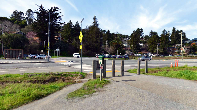
The following images are interactive. To get a sense of what people at the OWL site experienced, use the arrows to turn left and right, and up and down.
CURRENT CONDITIONS WITH A KING TIDE:
This is what Miller Avenue and the multi-use path looks like when we have a King Tide event. Communities along our bay shoreline already experience are this intermittent flooding. While infrequent, these temporary floods disrupt and inconvenience our day-to-day life.
When King Tides combine with a storm surge, as happened in December 2014, ocean levels temporarily rise up to three feet above normal. Roads and transit routes become impassable, stranding motorists and whole communities, utilities are at risk, and the marshes become inundated.
IN THE NOT-TOO-DISTANT FUTURE, THREE FEET OF PERMANENT SEA LEVEL RISE
As sea levels continue to rise, inundation will become more frequent, and will eventually be the “new normal” and our day-to-day life will be significantly impacted. Roads, highways and bridges, utilities and waste water treatment facilities, will all be affected, and there will be increasing costs to repair, relocate, or add resilience measures, which will have an effect on our economy, as well.
TWO POSSIBLE OPTIONS TO ADAPT TO RISING SEAS:
Lessening the impact of sea level rise on our communities requires that we choose how we want to prepare for this emerging reality. What options we choose will depend on what is physically and economically feasible, what the best solution might be for each location, and what our communities’ preferences are. These are long-term solutions that require all of us to be thinking and begin planning now. There are many ways to respond, including two ideas shown here.
A SEA WALL:
One option is a sea wall built high enough to protect against the kind of flooding you saw above.
Here's another way to envision what this would look like:
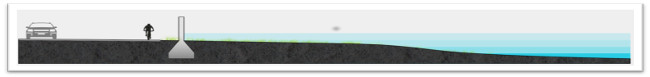
Some Pros and Cons:
- Sea walls are relatively narrow, meaning they don't occupy a large "footprint" on the landscape and can be used where other measures won't work
- Their performance is fairly predictable
- Sea walls are vulnerable to earthquakes and damage from storms
- They create a barrier between people and the environment around them
- They can have negative impacts on habitats and species
A HORIZONTAL LEVEE OR “ECO BERM”:
An adaptation option like this hybrid infrastructure allows communities to stay connected to their local natural environment while still protecting land behind the levee. A horizontal levee or eco-berm might include floodable terraces for recreational use while still offering significant natural habitat.
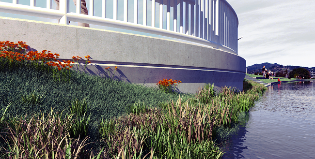
Here's a side-view:
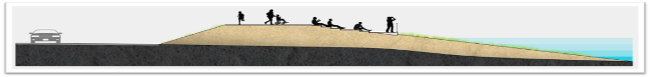
Some Pros and Cons:
• This approach protects against flooding and creates space for recreation activities, like walking, running and biking paths
• Levees and basic eco-berms take up more space than a sea wall, and expanded “green-scaping” requires even more, so this approach can’t be used everywhere
• These showcase the natural systems at play along the water’s edge
• This approach is more expensive than a sea wall
PLEASE NOTE: These simulations are simple examples, among many possibilities. There are no current plans to develop any of these scenarios in Marin, but some possible options will be considered for pilot tests. Any solutions that are eventually designed and employed will be the result of scientific analysis, best environmental, engineering, and technological practices, and a great deal of community input. These images are for the purposes of discussion, to help us all begin to imagine what the future will be like, and how to envision new ways of living with water in our landscapes and our live.