San Rafael, CA –High tides often cause flooding along shoreline communities and low-lying roadways of Marin County, particularly when coupled with winter storms. The Marin County Department of Public Works (DPW) and the Marin County Flood Control and Water Conservation District are urging residents and visitors to stay informed of changing weather conditions and be aware of expected high tides that might affect commuter schedules and holiday travel plans.
 Several locations in Marin, including this parking lot in Sausalito, have a history of flooding when tide levels pass into the mid-six feet range.
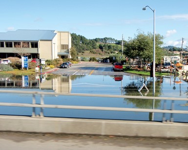
Based on tide predictions published by the National Oceanic and Atmospheric Administration (NOAA), tides levels that could be high enough to cause roadway flooding in parts of Marin, primarily coastal areas, are expected November 25-27 and December 23-25. Drivers are encouraged to consider using alternative routes and should allow extra time for trips, especially during peak commute times. Travelers should always avoid driving through ponded water, as even six inches of standing water can stall a low-clearance car.
The following chart shows predicted high tides at or above 6.3 feet during November and December at the San Francisco tide gauge, as provided by NOAA. If significant rainfall occurs during a high tide of 6.3 feet or more, the likelihood of localized flooding increases for coastal communities and other historically susceptible areas, such as North San Pedro Road through China Camp in outer San Rafael, Greenwood Cove Drive in Tiburon, and Manzanita Park & Ride in Tamalpais Valley Junction.
|
Saturday, November 23, 8:36 a.m.
|
6.3 feet*
|
|
Sunday, November 24, 9:14 a.m.
|
6.5 feet*
|
|
Monday, November 25, 9:52 a.m.
|
6.7 feet*
|
|
Tuesday, November 26, 10:30 a.m.
|
6.8 feet*
|
|
Wednesday, November 27, 11:09 a.m.
|
6.7 feet*
|
|
Thursday, November 28, 11:49 a.m.
|
6.4 feet*
|
|
Sunday, December 22, 8:02 a.m.
|
6.5 feet*
|
|
Monday, December 23, 8:45 a.m.
|
6.7 feet*
|
|
Tuesday, December 24, 9:26 a.m.
|
6.8 feet*
|
|
Wednesday, December 25, 10:07 a.m.
|
6.8 feet*
|
|
Thursday, December 26, 10:48 a.m.
|
6.6 feet*
|
|
Friday, December 27, 11:28 a.m.
|
6.4 feet*
|
| *Tide Elevation (Mean Lower Low Water) |
|
Future projections by the California King Tides Project indicate that annual king tides, which are extreme high tides, could become the normal tides as sea level rise continues. King tides occur when the earth, moon and sun are aligned to exert the maximum upward gravitational pull on the tides, thereby increasing overall water elevations. The project also predicts that there will be an increase in daily tidal flooding. In the same vein, the County of Marin released the Marin Shoreline Sea Level Rise Vulnerability Assessment in 2017, a comprehensive study that showed the expected impacts that sea level rise will have on flooding in the region.
An example of impacted infrastructure is the multiple closures of Highway 37 in the past few years. The route along the San Pablo Bay marshlands, which is under the California Department of Transportation’s (Caltrans) jurisdiction, is a crucial part of the North Bay’s road infrastructure. Studies are underway, including one by DPW, to assess the resiliency and potential solutions in the face of future sea level rise expectations.
The Manzanita Park & Ride Lot, located at the junction of Highways 101 and 1 and overseen by Caltrans, has a history of flooding when tide levels pass into the mid-six feet range. As in previous years, Caltrans sometimes has to close the lower half of the parking lot because of flooding.
Caltrans has installed two new tide gates in the area to help lessen the severity of flooding in the Manzanita area. In conjunction with the new Caltrans infrastructure, DPW and Flood District teams have installed a 175-foot-long sandbag wall along Highway 1, adjacent to the Caltrans maintenance yard, where flooding from the bay historically inundates the road.
As storms exacerbate high tides, DPW prepares year-round for the rainy season, conducting various maintenance tasks intended to help reduce the risk of flooding. In addition to maintenance tasks like creek clearing and storm drain cleaning, the Flood District has recently improved several infrastructure sites including a pump station in Tiburon and installation of new tide and creek level monitoring gauges.
Travelers can check 511.org for latest traffic and transit information. DPW’s Twitter, Marin County Sheriff’s Office’s Twitter, the California Highway Patrol (CHP) traffic website and CHP Marin’s Twitter are excellent resources for travelers and residents looking for updates during storm events. Additionally, weather gauges showing rainfall and tide elevations can be viewed in real-time at Marin County’s OneRain webpage.