San Rafael, CA – As a response to rising concerns about wildfire threats and the goal of keeping up with new technology, the Marin County Fire Department (MCFD) has installed new cameras at several mountaintop locations and connected their feeds to a new North Bay network that anyone may view online.
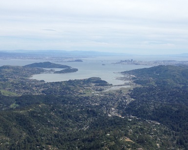 Mount Tamalpais, from which this view was captured, is one of the Marin peaks with new fire detection cameras.
MCFD worked with Sonoma and Napa counties,
Pacific Gas & Electric Company and
ALERTWildfire.org to create a comprehensive camera network that covers locations in three counties. PG&E paid approximately $5,000 per camera at six locations and County of Marin personnel installed them over the past month, replacing cameras that had been in place since 2014.
“There were some limitations to the old system, such as only receiving updated photos from the cameras every 15 minutes and having the cameras locked to show only one direction,” said MCFD Deputy Chief Mark Brown. “The current system allows us to move the cameras to the location of our choice and provides new images to the public every 20-30 seconds. This is a major upgrade, and the imagery is pretty amazing. So far this has been free to us, so we’re thankful to our partners for making it happen.”
Online viewers may check Marin cameras at Mount Tamalpais East, Mount Tamalpais West, Big Rock Ridge between San Rafael and Novato, Barnabe Peak East and Barnabe Peak West in the western San Geronimo Valley, and Mount Vision near Inverness.
“We have plans to install a camera on Mount Burdell in Novato within the next month or two, and we have other locations in mind for Phase 2 and Phase 3,” Brown said. “Expanding the network is a goal because response time and fire location accuracy are critical to suppression efforts. It is most often the first few hours of a wildfire when the most devastation occurs. These cameras really enhance the quick detection and intelligence gathering we need to help preserve life and property.”
ALERTWildfire is a consortium of the University of Nevada, the University of California at San Diego, and the University of Oregon (UO) to provide public access to modern fire cameras that can tilt, pan out and zoom in. The camera views are designed to help fire agency administrators and other first responders locate fires, monitor fire behavior, scale up or scale down emergency resources, and help with evacuation plans. The ALERTWildfire system has steadily expanded to five western states.
The website is hosted by the University of Nevada’s Mackay School of Earth Sciences & Engineering.
MCFD has six fire stations and personnel charged with protecting 251 square miles of unincorporated areas and almost 199,000 acres of State Responsibility Area (SRA).