San Rafael, CA – The County of Marin, eager to engage the public and increase awareness of environmental issues, has unveiled its new sea level rise (SLR) monitoring site along the Mill Valley-Sausalito multiuse pathway at Bothin Marsh.
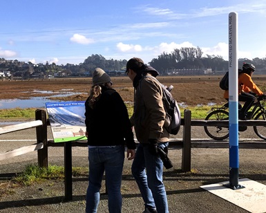 A sign and a pole help educate passers-by about sea level rise at Bothin Marsh.
Marin County ranks second out of the nine Bay Area counties in projected risk of SLR flooding, with potential infrastructure losses in the vicinity of $8.5 billion. During the past 120 years, the San Francisco tide gauge at the Golden Gate Bridge, the longest functioning gauge on the West Coast, has shown a rise of nearly eight inches. Based on predictions that there will be approximately five feet of SLR in the next 100 years, future generations will be most heavily impacted by today’s proactive measures.
The project is a collaborative effort with the County’s Department of Public Works (DPW), Community Development Agency, Marin County Parks, and several local agencies. Employees such as Chris Choo, DPW’s Principal Watershed Planner, have been devoting a commendable amount of time and effort to addressing climate change.
“It simply doesn’t matter what numbers you use – the fact is that we are already seeing an increase in flooding right now across the county,” Choo said. “We need to work together to share information and begin planning adaptation projects.”
Located along the bay shoreline a half-mile south of Tamalpais High School, the new SLR monitoring station at Bothin Marsh encourages “citizen science,” in which the public can become involved in gathering data. Citizen scientists take photos of the shoreline from a static platform and upload them onto social media sites with the hashtag #MarinSLR. Project staff can then utilize the image library as evidence of changing shoreline conditions.
To help educate and involve the community, the California Coastal Conservancy awarded $250,000 to the County in support of its collaborative efforts to engage municipal governments, local agencies, elected officials and the public on developing a Marin Bay Shoreline SLR Vulnerability Assessment. Two main SLR assessment projects are underway in the County – one that focuses on the coast (C-SMART) and one on the bayside (BayWAVE).
Recently the County received the Public Outreach Award from the American Planning Association for creating an innovative board game, The Game of Floods, which challenges the public to investigate SLR planning and solution implementation. In a similar spirit, the Youth Exploring Sea Level Rise Science (YESS) project is another effort intended to empower young people to engage in the climate change solutions within their own communities. Initiatives like those allow the public, including the youth who will face the brunt of climate change in the decades to come, to have a voice on the issue and spark a broader conversation about risk and resiliency.
More information on this topic and related programs can be found on the County’s SLR website.