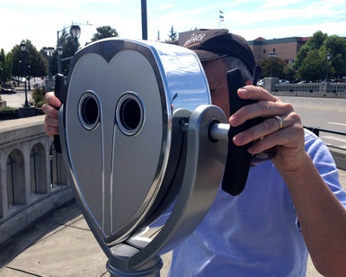
San Rafael, CA – Over four months, almost 4,000 visitors were wowed by the virtual-reality devices that were temporarily installed along the Mill Valley-Sausalito Multiuse Pathway to illustrate the gradual effects of sea-level rise. By looking into the OWL viewfinder, users saw what rising waters would look like in the future, putting a 21st century high-tech twist on 20th century viewfinder technology. Although the successful “OWL” pilot project has come to a close, the public education campaign about sea-level rise is ongoing.
 A community conversation about countywide sea-level rise adaptation strategies is set for 5:30 p.m. October 8 at the Mill Valley Community Center. Researcher Dr. Susanne Moser will facilitate the evening with Cara Pike of Climate Access, the non-profit partner in the OWL pilot project, along with the Federal Emergency Management Agency (FEMA) and the County of Marin. After an overview of the findings of the OWL project, staff from the County’s Departments of Public Works and Community Development Agency will present current and planned adaptation projects for discussion. Participants are invited to talk about some of the actions our communities can take to mitigate and adapt to the impacts of sea-level rise.
Statistics provided by Owlized, the San Francisco-based company that manufactured the OWL devices, show that the vast majority who used the interactive device (built to resemble old-fashioned coin-operated binoculars common at vista points) said they were somewhat, very or extremely concerned about sea-level rise.
County Planning Manager Jack Liebster has described sea-level rise as a “slow moving emergency” that over years could have devastating effects in Marin’s low-lying areas near the bay and the Pacific Coast, and impact the infrastructure that everyone depends on. County residents have already experienced initial impacts such as flooding during the king tides. According to the U.S. Geological Survey, 500,000 people, 1 million jobs, and $100 billion in property are threatened by sea-level rise along the California coast over the next century.
“We want to get prepared and develop ways to adapt to these changes so we can avoid suffering serious impacts in the future,” Liebster said. “Some of the responses we will need to consider have long lead times, and others may be required sooner. The people and communities who could be affected need to understand and consider the choices we all could face, and actively participate in how those choices are made.”
Residents, business leaders, environmental advocates, elected officials … all are encouraged to participate in this free event, as the County and the bayside cities collaborate on a vulnerability assessment for the San Francisco Bay shoreline areas.
Chris Choo, Senior Watershed Planner for the County, will be the project manager for the first phase of that effort in 2016.
“Our major roads, utilities, and communities built near the water's edge are vulnerable,” Choo said. “Climate change will require immense coordination and communication in Marin, the Bay Area, and at the state level. Now is the time to begin education, involvement, and listening to each other.”
The Mill Valley Community Center is at 180 Camino Alto in Mill Valley. Although the October 8 event is free to attend, there are limited spaces available, so RSVP online to save a spot.
Subscribe to receive e-mailed updates and find more information on www.MarinSLR.org.